Clouds are visible masses of water droplets or ice crystals suspended in the atmosphere. They are classified primarily by their shape, altitude, and weather characteristics. The World Meteorological Organization (WMO) provides a standardized system for cloud classification.
1. Classification by Altitude
Clouds are grouped into four main altitude-based categories:
High Clouds (Above 20,000 feet or 6,000 meters)
-
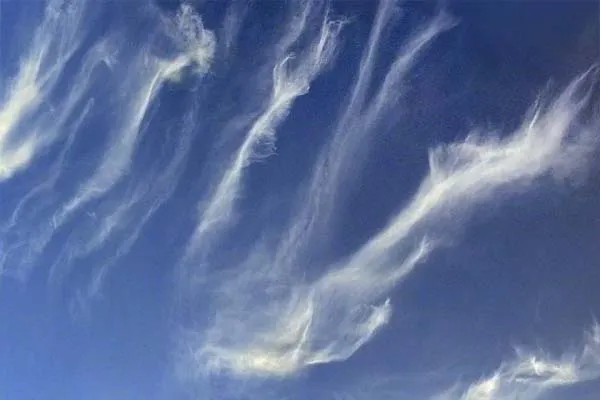
Cirrus (Ci): Thin, wispy, and feathery clouds made of ice crystals. Often indicate fair weather but can signal an approaching storm if they thicken.
-
Cirrostratus (Cs): Thin, sheet-like clouds that often cover the sky, creating a halo around the sun or moon. Usually indicate moisture and an approaching weather change.
-
Cirrocumulus (Cc): Small, white, patchy clouds arranged in rows, often with a rippled appearance. Rarely produce precipitation but may signal cold weather.
Mid-Level Clouds (6,500–20,000 feet or 2,000–6,000 meters)
-
Altostratus (As): Gray or blue-gray, uniform clouds that often cover the entire sky. They may produce light rain or snow and can obscure the sun.
-
Altocumulus (Ac): White or gray, puffy clouds with a wavy or rippled pattern. Often seen on warm, humid mornings and may precede thunderstorms.
Low Clouds (Below 6,500 feet or 2,000 meters)
-
Stratus (St): Low, gray, uniform clouds that often cover the sky like a blanket. Associated with drizzle or light rain and overcast weather.
-
Stratocumulus (Sc): Low, lumpy, spreading clouds with breaks of clear sky. Usually indicate fair weather but can produce light precipitation.
-
Nimbostratus (Ns): Thick, dark, low clouds that produce continuous rain or snow. Often associated with prolonged wet weather.
Vertically Developed Clouds (Span multiple altitude levels)
-
Cumulus (Cu): Puffy, white clouds with flat bases, often seen on clear, sunny days. Indicate fair weather but can develop into larger clouds.
-
Cumulonimbus (Cb): Towering, anvil-shaped clouds that span from low to high altitudes. Associated with thunderstorms, heavy rain, lightning, and sometimes hail or tornadoes.
2. Classification by Shape and Structure
Clouds are also described by their appearance:
-
Strato-: Layered, spread-out clouds (e.g., Stratus, Altostratus).
-
Cumulo-: Puffy, heaped clouds (e.g., Cumulus, Altocumulus).
-
Cirro-: High, wispy clouds (e.g., Cirrus, Cirrostratus).
-
Nimbo-: Rain-producing clouds (e.g., Nimbostratus, Cumulonimbus).
3. Special Cloud Types
Some clouds are less common or have unique characteristics:
-
Lenticular (Altocumulus Lenticularis): Lens-shaped clouds formed near mountains, often resembling UFOs.
-
Mammatus: Pouch-like clouds hanging beneath cumulonimbus, indicating turbulent weather.
-
Noctilucent: Rare, high-altitude clouds visible at twilight, composed of ice crystals in the mesosphere.
-
Contrails: Man-made clouds formed from aircraft exhaust at high altitudes.
4. Cloud Formation and Weather
Clouds form when moist air rises, cools, and condenses. Their type and behavior provide clues about weather:
-
Fair Weather: Cumulus, Cirrus, Stratocumulus.
-
Approaching Storms: Cirrostratus, Altostratus, Cumulonimbus.
-
Persistent Rain/Snow: Nimbostratus, Stratus.